![[]](https://theparkerfamily.org/wp-content/uploads/2010/08/4921848712_e7c6e7a8c6.jpg)
![[]](https://theparkerfamily.org/wp-content/uploads/2010/08/4921849428_c703fdde80.jpg)
![[]](https://theparkerfamily.org/wp-content/uploads/2010/08/4921252165_c7f70faa8a.jpg)
![[]](https://theparkerfamily.org/wp-content/uploads/2010/08/4921844606_ee63f103dd.jpg)
See All the Photos on Flickr:
sky meadows state park, delaplane, virginia
sky meadows state park, delaplane, virginia
![[]](https://theparkerfamily.org/wp-content/uploads/2010/08/4908001335_d78c3b0110.jpg)
![[]](https://theparkerfamily.org/wp-content/uploads/2010/08/4908000101_785e34ec31.jpg)
![[]](https://theparkerfamily.org/wp-content/uploads/2010/08/4907998943_b364c65815.jpg)
![[]](/wp-content/uploads/2010/07/4777759873_bdb10b6a84.jpg)
![[]](/wp-content/uploads/2010/07/4777755351_6a7a8c4e13.jpg)
![[]](/wp-content/uploads/2010/07/4777758117_b00d675518.jpg)
![[]](/wp-content/uploads/2010/06/4733794662_b85f2fb172.jpg)
trail information:
Trailhead: 38.997516,-77.255065 (Google Maps); Length: 1.8 total miles; Elevation Gain: < 100 feet; Trail Type: Loop (Canal Trail, to Matildaville Trail, to Old Carriage Road); Skill Level: Easy.
I’ve often joke with the lady sparkler that boys have it harded than girls getting ready for a baby. girls have a constantly growing reminder that something is about to change. boys just have longer-than-usual home improvement list, and the odd sensation that their wife is putting on a couple extra pounds.
not to mention, boys aren’t that good at sensing or reflecting anyway.
but, that’s why i’m at susquehanna state park. located about 30 miles north of baltimore, it has always been my favorite hike, and i’ve been so many times — half a dozen in the last decade — that it’s become a place for me to measure the passage of time, relationships and all sorts of personal milestones.
as our due date edges close and closer, it’s been dawning on me that somethings are about to change. I’ll no longer have the lady sparkler all to myself. I’ll probably be way more focused on other’s bodily functions than my own.
that being said, I will soon have a beautiful daughter to share beautiful places and beautiful afternoons just like this one. I’ll also have a dumptruck-sized load of perspective that I’m pretty sure I’ve lacked up til now.
but the beautiful hike has cleared my head, and even if there are a couple small things left to wrap up before sparklet arrives, I’m ready. I have a wonderful wife, we have a wonderful family, and are surrounded by wonderful friends.
I can’t think of a better world to bring our little sparklet into.
of course, when you are on a rock with no identifiable markings (you know, like a trail or something) one tends to get lost. but fortunately, one also tends to have a brand-spanking new iphone with gps integrated google maps to bail oneself out. again.
but i still added about two hours to my hike by unexpectedly coming down the backside of the mountain, but the sky was blue and the weather was freexzing cold (by texas standards) so no harm, no foul.
 |
 |
 |
 |
 |
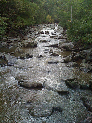
it turns out that rock creek park (of Chandra Levy fame) has a network of trails … *actual* trails with switchbacks, elevation gain, wildlife, streams, and mud. not just the paved rec paths or glorified sidewalks you would imagine in a city park.
it amazes me that residents of Mt. Pleasant won’t shut up about the glory that is the National Zoo — though it is pretty awesome — and yet they neglect to mention the National Park-grade liking trails less than three blocks away.
even more stupefying is that we had the trails to our selves. sans a couple or dog owners and a pair of septuagenarians warning us about the perils of poison ivy (they had just been interviewed by News Channel 8 on the topic) there was nary a human in sight on a stunningly beautiful Sunday afternoon.
there are two main trails around the park … the western ridge trail and the valley trail. we looped through the bottom third of both in about two hours. the trails go from the Zoo all the way up to Maryland, but we weren’t that brave (and, frankly, should have been in better shoes).
we did get lost (yes, in rock creek park) and used my fancy-pants new iPhone’s GPS locator-thingy to save our bacon. I’d like to think that the coolness of the iPhone balances embarrassment of actually using it in the “wilderness” … but, sadly, it’s still just humiliating.
speaking of maps, those provided by the Park Service show the trails as one unintelligible smudge, which makes navigation (without an iPhone) that much more exciting. there are larger, more printer friendly rock creek trail maps here:
Map: Hiking Trails in Rock Creek Park (South)
Map: Hiking Trails in Rock Creek Park (North)
Explore the Photoset:
Hiking in Rock Creek Park, Washington, DC
![[Susquehanna State Park, Havre de Grace, Maryland]](https://theparkerfamily.org/wp-content/uploads/2009/10/4017756159_738e043718.jpg)
![[Photo]](https://theparkerfamily.org/wp-content/uploads/2008/11/3064890744_31673c7cc5.jpg)
![[Photo]](https://theparkerfamily.org/wp-content/uploads/2008/11/3064422728_5392e52e02.jpg)
![[Photo]](https://theparkerfamily.org/wp-content/uploads/2008/10/2940549118_d1a7af0174.jpg)
i haven’t looked it up yet, but the 2 mile trail we just did had enough altitude gain that it might as well been the north face of mount everest, as least as far as my frail body/flabby midsection was concerned.
and, sparklet was unkind — providing very verbal feedback every 10 feet when her daddy/sherpa stopping to suck wind.
the big news of the morning came on the way back down, when we ran smack into a herd of cows — animals, i should point out, that didn’t seem to be having a problem with the altitude.
we ran into them right as we were coming over a blind rise, so by the time sparklet saw them they were maybe 10 feet away, and she was utterly confounded about how a whole pack of her friends from the petting zoo got up here (and how she got on the wrong side of the fence, i’d imagine).
after about 10 minutes of staring (with a competition between sparklet’s eyes and her mouth for which could be open the widest) we finally said goodbye to the cows and continued on.
sparklet wailed, until we turned back.
after 5 more minutes of staring (and waving, and giggling) we once again said goodbye to the cows and continued on.
sparklet wailed.
it wasn’t until three more rounds of this that the cows were far enough away that sparklet finally lost interest in her first official “wildlife” sighting.
and, being the out-of-shape/selfish nit that i am, the whole time i was wondering why we couldn’t have seen the cows on the way UP the mountain, when i could have used the excuse to stop.
trail information:
Trailhead: 38.992886,-77.967272 (Google Maps); Length: 2.1 total miles; Elevation Gain: 360 feet; Trail Type: Out-and-back; Skill Level: Moderate.