hike: scott’s run preserve

Sparklet is 2 years and 24 days old

Tags

Author

Comments

[]
[]
[]
[]
[]
See Slideshow of the Photos on Flickr:
hike: scott’s run nature preserve, mclean, virginia

hike: glover archibald trail

Sparklet is 2 years and 23 days old

Tags

Author

Comments

[]
[]
[]
See Slideshow of the Photos on Flickr:
hike: glover archibald trail, washington, dc

hike: cabin john trail

Sparklet is 1 year, 9 months and 25 days old

Tags

Author

Comments

[]
[]
[]
[]
[]
See Slideshow of the Photos on Flickr:
hike: cabin john trail, potomac, maryland

flexday: cabin john, maryland

Sparklet is 1 year, 9 months and 5 days old

Tags

Author

Comments

[]
[]
[]
[]
See Slideshow of the Photos on Flickr:
hiking, c&o canal towpath, cabin john, maryland

hike: great falls, maryland

Tags

Author

Comments

[]
[]
[]
See Slideshow of the Photos on Flickr:
hike: great falls, maryland

hike: parque nacional volcon arenal, costa rica

Sparklet is 1 year, 1 month and 24 days old

Tags

Author

Comments

[]
[]
[]
we are lucky people.

putting aside the fact that we can afford to come to costa rica, that we both work with such awesome people that we can just dissappear for 10 days during the run up to year end, and that we have a (mostly) happy, healthy and charming little girl …

… during the roughly 108 hours that we’ve been in Arenal, we’ve been able to see the very top of the volcano for exactly six hours — and three of those hours happend to be when we were hiking around the base of the volcano.

i don’t want to run the statistical odd of this ever happening again, but i do feel like i should buy a lottery ticket.

the main hike in the parque is about 2km from the primary parking lot to a (now fully cooled) lava flow from the 1993 eruption, which goes through a whole series of overlooks of both the volcano and the lake beneath.

we knew nothing about how strenuous the hike was, but started feeling good when we saw two Russian grandmothers hobbling off the mountain as we made our way to the trail head.

sparklet was a happy (and well fed) camper in throughout — and even hiked a bit herself on the way back.

she’s a good egg.

See Slideshow of the Photos on Flickr:
hike: parque nacional volcon arenal, costa rica

hike: knob mountain / elkwallow trails, shenandoah national park, virginia

Sparklet is 1 year, 1 month and 7 days old

Tags

Author

Comments

[]
[]
[]
it’s interesting how the camera only seems to capture when the lady sparkler is wearing the backpack.

i’m calling this the last hike of the season — and while i hope it’s not actually going to turn out that way, it is getting pretty late into November. and, while we *are* taking the backpack to Costa Rica, based on the events of today i’m not convinced we’re going to use it much.

granted, sparklet had never been on a hike for longer than an hour and a half, and the lady sparkler had been on one hike since she got pregnant two years ago, but needless to say, it didn’t go especially well today.

note to self: (1) bring more food; (2) go over the trail details with your wife beforehand especially if she pretends not to care; (3) bring earplugs just in case you happen to fail on notes #1 and/or #2.

trail information:
Trailhead: 38.73885, -78.308208 (Google Maps); Length: 5.7 total miles; Elevation Gain: 800 feet; Trail Type: Loop (Jeremy’s Run Trail, to Knob Mountain Trail, to Elkhollow Trail); Skill Level: Easy-to-moderate.

hike: limberlost trail, shenadoah national park, virginia

Sparklet is 1 year and 29 days old

Tags

Author

Comments

[]
photo of the week // thirteen months
[]
[]
trail information:
Trailhead: 38.579997,-78.381389 (Google Maps); Length: 1.3 total miles; Elevation Gain: 100 feet; Trail Type: Loop; Skill Level: Easy.
See Slideshow of the Photos on Flickr:
hike: limberlost, shenandoah national park, virginia

hike: snead farm, shenandoah national park, virginia

Sparklet is 11 months and 29 days old

Tags

Author

Comments

[]
[]
trail information:
Trailhead: (Google Maps); Length: 3.2 total miles; Elevation Gain: 500 feet; Trail Type: Loop; Skill Level: Easy.
See Slideshow of the Photos on Flickr:
hike: snead farm, shenandoah national park, virginia

hike: schaeffer farm, seneca creek state park, maryland

Sparklet is 11 months and 6 days old

Tags

Author

Comments

[]
[]
[]
trail information:
Trailhead: 39.142838, -77.310373 (Google Maps); Length: 3.5 total miles; Elevation Gain: Minimal; Trail Type: Loop; Skill Level: Easy.

hike: stony man trail, shenandoah national park, virginia

Sparklet is 10 months and 21 days old

Tags

Author

Comments

[]
[]
[]
trail information:
Trailhead: 38.589168, -78.374405 (Google Maps); Length: 1.6 total miles; Elevation Gain: 320 feet; Trail Type: Loop; Skill Level: Easy.
See a Slideshow the Photos on Flickr:
stony man mountain, shenandoah national park, virginia

hike: piedmont/gap run trails, sky meadows state park, virginia

Sparklet is 10 months and 10 days old

Tags

Author

Comments

[]
[]
[]
[]
damn, i’m out of shape.

i haven’t looked it up yet, but the 2 mile trail we just did had enough altitude gain that it might as well been the north face of mount everest, as least as far as my frail body/flabby midsection was concerned.

and, sparklet was unkind — providing very verbal feedback every 10 feet when her daddy/sherpa stopping to suck wind.

the big news of the morning came on the way back down, when we ran smack into a herd of cows — animals, i should point out, that didn’t seem to be having a problem with the altitude.

we ran into them right as we were coming over a blind rise, so by the time sparklet saw them they were maybe 10 feet away, and she was utterly confounded about how a whole pack of her friends from the petting zoo got up here (and how she got on the wrong side of the fence, i’d imagine).

after about 10 minutes of staring (with a competition between sparklet’s eyes and her mouth for which could be open the widest) we finally said goodbye to the cows and continued on.

sparklet wailed, until we turned back.

after 5 more minutes of staring (and waving, and giggling) we once again said goodbye to the cows and continued on.

sparklet wailed.

it wasn’t until three more rounds of this that the cows were far enough away that sparklet finally lost interest in her first official “wildlife” sighting.

and, being the out-of-shape/selfish nit that i am, the whole time i was wondering why we couldn’t have seen the cows on the way UP the mountain, when i could have used the excuse to stop.


trail information:

Trailhead: 38.992886,-77.967272 (Google Maps); Length: 2.1 total miles; Elevation Gain: 360 feet; Trail Type: Out-and-back; Skill Level: Moderate.

See All the Photos on Flickr:
sky meadows state park, delaplane, virginia

hike: fox hollow, shenandoah national park, virginia

Sparklet is 10 months and 6 days old

Tags

Author

Comments

[]
[]
[]
trail information:
Trailhead: 38.624113, -78.288574 (Google Maps); Length: 1.2 total miles; Elevation Gain: 310 feet; Trail Type: Loop; Skill Level: Easy.

hike: tall poplar trail, patapsco valley state park, maryland

Sparklet is 8 months and 26 days old

Tags

Author

Comments

[]
[]
[]
trail information:
Trailhead: 39.357479, -76.887839 (Google Maps); Length: 1.4 total miles; Elevation Gain: 160 feet; Trail Type: Loop; Skill Level: Easy.

hike: matildaville trail, great falls national park, va

Sparklet is 8 months and 12 days old

Tags

Author

Comments

[]
sparklet’s first hike. didn’t make it long (45 minutes) or far (definitely short of two miles) but it mostly worked. she hates wearing a hat, tho — that lasted all of about 30 seconds.

trail information:
Trailhead: 38.997516,-77.255065 (Google Maps); Length: 1.8 total miles; Elevation Gain: < 100 feet; Trail Type: Loop (Canal Trail, to Matildaville Trail, to Old Carriage Road); Skill Level: Easy.

the next chapter

The Lady Sparkler is 37 weeks pregnant

Tags

Author

Comments

[Susquehanna State Park, Havre de Grace, Maryland]
ECPA20091012_2439, originally uploaded by [ecpark].
i had the day off today (some kind of national holiday honoring the beginning of the end of Native American civilization) which conveniently doubled as one of my last chances for a solo hike in the near- to mid-future.

I’ve often joke with the lady sparkler that boys have it harded than girls getting ready for a baby. girls have a constantly growing reminder that something is about to change. boys just have longer-than-usual home improvement list, and the odd sensation that their wife is putting on a couple extra pounds.

not to mention, boys aren’t that good at sensing or reflecting anyway.

but, that’s why i’m at susquehanna state park. located about 30 miles north of baltimore, it has always been my favorite hike, and i’ve been so many times — half a dozen in the last decade — that it’s become a place for me to measure the passage of time, relationships and all sorts of personal milestones.

as our due date edges close and closer, it’s been dawning on me that somethings are about to change. I’ll no longer have the lady sparkler all to myself. I’ll probably be way more focused on other’s bodily functions than my own.

that being said, I will soon have a beautiful daughter to share beautiful places and beautiful afternoons just like this one. I’ll also have a dumptruck-sized load of perspective that I’m pretty sure I’ve lacked up til now.

but the beautiful hike has cleared my head, and even if there are a couple small things left to wrap up before sparklet arrives, I’m ready. I have a wonderful wife, we have a wonderful family, and are surrounded by wonderful friends.

I can’t think of a better world to bring our little sparklet into.

hike: mirror lake, oregon

Tags

Author

Comments

[Photo]
IMG_7035, originally uploaded by [ecpark].
Explore the Photo Set:
hike: mirror lake, oregon

hike: enchanted rock state park, texas

Tags

Author

Comments

[Photo]
IMG_6080, originally uploaded by [ecpark].
after three days in austin for a non-profit technology conference, i headed for the hills today for a hike around enchanted rock state park near oxford, texas. it’s a giant monolith in the middle of the texas hill country, and completely unlike anything else around.

of course, when you are on a rock with no identifiable markings (you know, like a trail or something) one tends to get lost. but fortunately, one also tends to have a brand-spanking new iphone with gps integrated google maps to bail oneself out. again.

but i still added about two hours to my hike by unexpectedly coming down the backside of the mountain, but the sky was blue and the weather was freexzing cold (by texas standards) so no harm, no foul.

hike: sky meadows state park, virginia

Tags

Author

Comments

[Photo]
ECPA20081011_5591, originally uploaded by [ecpark].

hike: cape henlopen, delaware

Tags

Author

Comments

See All the Photos on Flickr:
cape henlopen state park, delaware

hiking in rock creek park (why we love dc #9)

Tags

Author

Comments

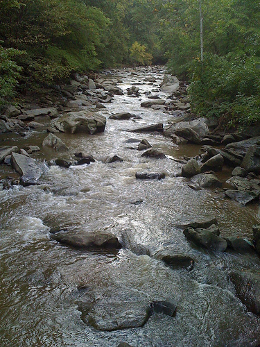
it turns out that rock creek park (of Chandra Levy fame) has a network of trails … *actual* trails with switchbacks, elevation gain, wildlife, streams, and mud. not just the paved rec paths or glorified sidewalks you would imagine in a city park.

it amazes me that residents of Mt. Pleasant won’t shut up about the glory that is the National Zoo — though it is pretty awesome — and yet they neglect to mention the National Park-grade liking trails less than three blocks away.

even more stupefying is that we had the trails to our selves. sans a couple or dog owners and a pair of septuagenarians warning us about the perils of poison ivy (they had just been interviewed by News Channel 8 on the topic) there was nary a human in sight on a stunningly beautiful Sunday afternoon.

there are two main trails around the park … the western ridge trail and the valley trail. we looped through the bottom third of both in about two hours. the trails go from the Zoo all the way up to Maryland, but we weren’t that brave (and, frankly, should have been in better shoes).

we did get lost (yes, in rock creek park) and used my fancy-pants new iPhone’s GPS locator-thingy to save our bacon. I’d like to think that the coolness of the iPhone balances embarrassment of actually using it in the “wilderness” … but, sadly, it’s still just humiliating.

speaking of maps, those provided by the Park Service show the trails as one unintelligible smudge, which makes navigation (without an iPhone) that much more exciting. there are larger, more printer friendly rock creek trail maps here:

Map: Hiking Trails in Rock Creek Park (South)
Map: Hiking Trails in Rock Creek Park (North)

Explore the Photoset:
Hiking in Rock Creek Park, Washington, DC

travel: discovery bay national park, victoria

Tags

Author

Comments

[Photo]
IMG_9584, originally uploaded by [ecpark].
Austalia (Day Seven) — Today we had two of the best hikes of the trip so far, both through Discovery Bay National Park, which runs along the Southern Ocean on the western edge of Victoria.

On our way back from the second, we ran into three billy goats (“gruff” presumably) in the middle of the path. Don’t know where they came from — they weren’t anywhere to be seen on the way out — but they were sure enough there on the way back. Initially, things didn’t look particularly good … the biggest one of the bunch approached slowly, dipped its head, and started pawing the ground.

Perhaps, now is a good time to pause for some back-story:

Last year when the lady sparkler and I were in Tucson, we mis-timed one of our hikes and found ourselves out in the desert after dark. As we were scurrying back, we had not one but two rattlesnakes try and kill us. The second of the two actually rattled across the path between the lady sparkler (who stopped) and myself (who sped up).

Yesterday, we were hiking around Mount Richmond in the middle of the day, when I noticed a large tree branch that was down across the path began to move. We’d find out later that it was actually a copperhead, one of the 14 breeds of snakes in Australia that can kill you. Now, when you think copperhead, you think of a normal-sized snake that just happens to be poisonous. This, however, was the size of the basilisk from that Harry Potter movie. It looked like it had recently eaten a moose. Or an auto.

Anyway, back to the goats. The only thing that kept me from running around like a blithering idiot around the snakes — other than the whole “being paralyzed with fear” thing — was that I keep being told that they are just as scared of us as we are of them. The goats? Not afraid of us, though, this turned out to be a good thing.

Momma goat DID dip her head, and pawed the ground, but was just looking to soften up the dirt before she laid down to completely block the path. Her two chil’en quickly followed suit. We gingerly chose about a 6 inch path between the goats and the 200-foot cliff, and resisted the urge to pet the (now) cute little goats. Didn’t want to open ourselves up to *that* conversation with Customs.

Turns out that not everything in Australia is trying to kill you.

hike: roosevelt island, washington, dc

Tags

Author

Comments

[Photo]
IMG_7889, originally uploaded by [ecpark].
the lady sparkler and i set out at about 1 pm for the great western woods, but after 30 blocks of remarkably abysmal traffic, we were still in D.C. at 2:30 pm. so, we regrouped and walked around roosevelt island, a national park in the potomac between rosslyn and georgetown.

hike: the remains of the foliage

Tags

Author

Comments

[Photo]
IMG_7860, originally uploaded by [ecpark].
We completely missed peak foliage this year, because of the whole wedding/honeymoon thing … so on our first real weekend back, we headed out in search of what was left of the leafs to peep.

First thing we learned was to not trust state tourism department’s web sites. It makes sense with hindsight, but both Virginia and Maryland seem to have incentive to be less then honest about the status of the foliage in their respective purviews. In their “foliage reports,” they used words like “spectacular” and “peak” that roughly translated to “intermittent” and “you should have visited two weeks ago.”

The only people who seemed to have a clue about what was going on was The Weather Channel, which has a forecast map showing the state of the foliage on the ground. This turned out to be the most correct, largely because it said that vast majority of the country is, in fact, “past peak”.

In search of what was left, we drove out to Elk Neck State Park in Maryland, which is situated right on the northern tip of the Chesapeake Bay. The drive in had some widespread (but muted) foliage, but there wasn’t anything — and I mean anything — once we go into the park itself. From there, we headed 20 miles west of Baltimore to Morgan Run Natural Environment Area. While the drive in wasn’t as pretty as in the far northeast of the state, the hiking was great.

From all reports, this just isn’t going to be a good year for foliage. I found a great write-up on what makes for good foliage, and we just didn’t have the wet growing season and dry, sunny fall needed for anything other than muted, muddy leaf peeping.

travel: actun tunichil muknak, belize

Tags

Author

Comments

IMG_0695, Entrance to the Cave, Actun Tunichil Muknak, Tapir Mountain Nature Reserve, Belize
IMG_0695, originally uploaded by [ecpark].
Our last excursion in Belize was to a cave system about an two-hours outside of Chaa Creek. Called Actun Tunichil Muknak (or A.T.M. for short), the caves were used by the Mayans as a place of worship.

After driving out towards the A.T.M., we parked the van and hiked 45 minutes to the mouth of the caves. Once there, we hopped into the river flowing out of the cave, and swam inside. After about 100 yards, the water was shallow enough to stand up. After hiking through the water for about half a kilometer, we climbed out of the river and spent an hour walking through the formations which 2,000 years earlier were a Mayan burial ground.

The whole day was spectacular, not just the journey, but the formations and especially the Mayan artifacts left untouched for over two millennia.

Explore the Photo Set:
Actun Tunichil Muknak, Belize
Newer Entries